|
The easternmost settlement in London south of the Thames, situated north of Barnes Cray, and not held in high regard by most
Bexleyites. This was formerly the manor of Howbury, recorded simply as Hov in Domesday Book, from the Old English ‘hōh’,
a heel of land. Slade Green was first mentioned in the 16th century, but the name is probably of earlier origin. A ‘slade’
was ‘a little dell or valley; or a flat piece of low, moist ground’ and it was certainly the latter meaning that
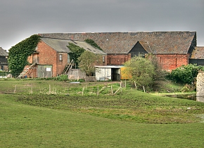
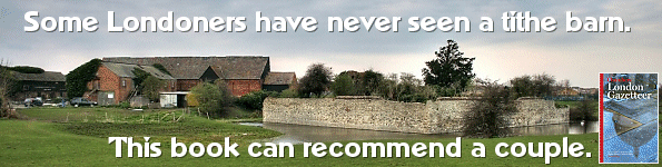
applied here. The ruins and moat of the house called Howbury constitute a scheduled ancient monument and a Jacobean tithe
barn survives, but in deteriorating condition. Howbury’s surroundings were fields on the edge of Crayford Marshes until
industrial development began here in the late 19th century, mainly in the form of brickmaking and barge-building. The bulky
Church of St Augustine was built in 1900, and the station opened in the same year, followed by locomotive sheds and carriage
sidings. The South East and Chatham Railway Co. built a small estate of railway workers’ homes and a matching public
house on Oak Road. The cottages are arranged in groups of four and designed to look at first glance as though each set is
a single dwelling. Prolonged railway ownership kept the Oak Road estate relatively unspoilt and it is now a conservation area.
The council built flats, bungalows, semi-detached houses and shops in the late 1950s. The system-built flats were demolished
around 1990 and replaced by much more pleasant housing. Bellway Homes received permission to build homes off Slade Green Road
in the mid 1990s in return for providing the Ray Lamb Way relief road. Barratts built the Watermead Park estate on reclaimed
marshland later in the decade.
|