|
A mixed Metroland and municipally built suburb covering a large area north-east of Wembley and west of Hendon. Known in ancient
times as Tunworth, it was mentioned in Domesday Book as Chingesberie, which meant ‘king’s manor’, although whatever royal connection it may have had seems to
have been lost by the time the Normans arrived. The disused twelfth century church is an indication of Kingsbury’s significance
as a medieval settlement and an inscription at the police station records how local disputes were resolved by representatives
from much of the modern borough. The growth of Kingsbury has seesawed between its southern and northern extremities. Kingsbury
was first a village beside Black Pot Hill (now Blackbird Hill), and Kingsbury Green was a hamlet one mile to its north. Kingsbury
was severely affected by the Black Death. The old village was largely abandoned; a new one grew up around Kingsbury Green
and by the late nineteenth century the original village was almost forgotten.
Victorian development was substantial enough for Kingsbury to break away from Wembley in 1900 as an independent urban district.
However, the separation lasted only 34 years and the district remained predominantly rural until well into the twentieth century.
In the 1920s Neasden and Kingsbury station (as was) stimulated Metroland growth in the southern part of Kingsbury and the population increased
eightfold in ten years. Immediately after this came the last stage of the Metropolitan Railway, from Wembley Park to Stanmore,
and the opening of the underground station, to the west of Kingsbury Green in 1932, whereupon the town’s centre of gravity
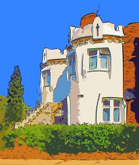
shifted once more. A further spate of private building included some delights by EG Trobridge in Slough Lane and Buck Lane.
Because Kingsbury is not a highly desirable area, most of Trobridge’s enchanting homes are not in the condition they
deserve to be. After the war, Wembley council built a major housing estate, destroying most of Kingsbury’s historic
buildings in the process.
|