|
|
 |
|
Hounslow
|
|
|
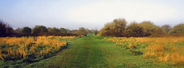
A large open space situated to the east of the River Crane in south-west Hounslow, including a public golf course and nurseries.
From the early thirteenth century the removal of tree cover on the ‘Warren of Staines’ began to create the bleakest
terrain in Middlesex, which eventually stretched from Brentford to beyond the western boundary of modern London. Rudimentary
agricultural usage developed after Henry VIII divided the land among fourteen parishes in 1546. On more than one occasion
great armies were mustered here, including those of Oliver Cromwell and James II. In the seventeenth century the heath covered
25 square miles and was peppered with gibbets, erected for its notorious highwaymen. By the start of the nineteenth century
it still encompassed 5,000 acres but a combination of enclosure acts and the exercise of squatters’ rights rapidly diminished
it. “Hounslow Heath,” wrote William Cobbett in 1830, “… is a sample of all that is bad in soil and
villainous in look. Yet this is now enclosed, and what they call ‘cultivated’. Here is a fresh robbery of villages,
hamlets and farm and labourers’ buildings and abodes!” Sand and gravel mining began in the mid-nineteenth century,
wreaking further damage on the natural habitat.
|
|
|
|
|
|
|
In 1919 Hounslow Heath became the site of the first civil airport in the country. The earliest commercial flight was from
Bristol to Hounslow and the inaugural scheduled air service was from Hounslow to Paris. On 12 November the first flight to
Australia left Hounslow, arriving 28 days later. Commercial aviation moved to Croydon in 1920 and the airport closed. Its
buildings were destroyed by fire in 1929 but a plaque in Staines Road marks the site. Gravel extraction continued until about
1976, with the resulting craters filled with domestic refuse. A regeneration programme has subsequently restored around 200
acres of heathland, with gorse, broom and rushes. In 1991 the majority of the site was designated a statutory local nature
reserve. A municipal golf course has been laid out on the heath’s western edge and the unsightly tower blocks of Richmond
council’s Hounslow Heath estate have claimed the south-eastern corner.
Hounslow Heath is also an electoral ward. Almost half the residents of the ward are Asian or Asian British, and the Christian,
Hindu, Muslim and Sikh faiths are all well represented.
|
|
|
|
|
|
|
Postcode areas: Hounslow, TW3 and TW4
Population: 11,115
Further reading: Gordon S Maxwell, Highwayman’s Heath: Story in Fact and Fiction of Hounslow Heath in Middlesex, Heritage
Publications/Hounslow Leisure Services, 1994 (reprint of a 1935 publication)
Text and selected images are reproduced with the permission
of Chambers but may differ from the published versions
All content © 2005–2010
|
|
|
|