|
Possibly the most desirable part of this sprawling suburb and the last to be built up, West Acton remained rural at a time
when South Acton was already becoming a slum. John Cary’s Middlesex map of 1786 reveals no indication of habitation
between Tile Kiln House on Hanger Lane and Fryes Place, east of Horn Lane. Ten years later, West Lodge was built on the south
side of Uxbridge Road. To its north, an 1805 map shows a set of fields belonging to Sir Harry Featherstonehaugh. In 1876 James
Thorne observed that much of Acton had already succumbed to bricks and mortar but, “on the west are some pretty lanes.”
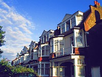
Suburban housebuilding here began on the eastern edge of Ealing, when semi-detached houses went up on the West Lodge estate
in the first decade of the twentieth century. The lodge itself is still standing but has been converted to office use. The
1920s brought the improvements in communications that would transform the area. West Acton station opened on the newly extended
Central Line in 1923 and later in that decade the Western Avenue made London easily accessible by road. Noel Road was one
of the first new streets to be completed, with semi-detached properties priced to appeal to the middle market – around
£800. In 1924 a subsidiary of the Great Western Railway Company laid out an estate of appealing little houses and some shops
near the main railway line. Reserved for railwaymen, the homes were designed by GWR architect T Alwyn Lloyd, a protégé of
Raymond Unwin. West Acton school opened on Noel Road in 1937. By the outbreak of the Second World War today’s West Acton
had largely taken shape. As well as the usual smattering of young professionals and antipodean flat-sharers, West Acton now
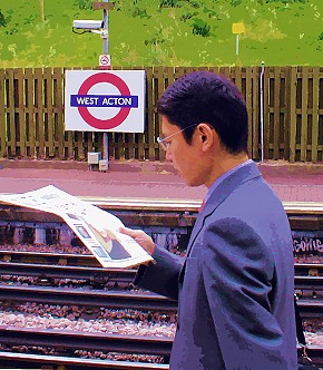
has Japanese families who want to be near the Japanese school in Creffield Road.
 |