|
|
 |
|
Haringey/Islington
|
|
|
‘An interesting, not very well known, Victorian urban landscape’, according to local historian Ken Gay, situated
north of Finsbury Park station and south of Hornsey Vale. The name is of 15th-century origin and indicated a marshy place
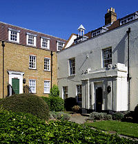
overgrown with brushwood. The first large building here was Stapleton Hall (shown below), which was built in 1609 for Sir
Thomas Stapleton, possibly on the site of an earlier house. The hall became a pub in the 18th century and had an 80-acre farm
in the mid-19th century. Its owner at that time was reluctant to sell the land for development but the coming of the railway
made this such a profitable prospect that he could no longer resist. Housebuilding began around 1870 and spread from Stroud
Green Road (originally Tollington Lane) north-eastward into Hornsey parish, with the grandeur of the terraced streets increasing
as the new district thrived. Three storeys became the norm. Most of the streets have names with royal associations –
Cornwall Road, for example, is named for the duchy, not the county itself. Stroud Green gained its own station in 1881, on
the Edgware, Highgate and London line, with shops and coal delivery offices around it. Such was the density of building that
newish houses had to be demolished to make way for Stroud Green school in 1897. Stroud Green station closed in 1954 and the
railway track has now become the Parkland Walk. Stapleton Hall was converted to apartments and given new wings in 1989. Many
houses have been subdivided and the locality is favoured by young graduates. In 2002 the Finsbury Park Business Forum’s
co-ordinator optimistically declared, ‘We can really see Stroud Green Road becoming the next Upper Street … but
[we will] make sure it retains its multicultural flavour.’
 |
|
|
|
|
|
|
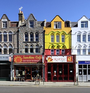
| Stroud Green Road |
Although mainly white, Stroud Green has significant black Caribbean and African minorities. At Stroud Green primary school
the main languages, other than English, are Turkish, Yoruba, French and Twi-Fante, which is spoken primarily in southern Ghana.
More than half of 16 to 74-year-olds in Stroud Green are qualified to degree level or higher, 60 per cent of the adults are
single and almost a third have no religion – exceptionally high figures.
|
|
|
|
|
|
|
Postal district: N4
Population: 10,324 (Haringey’s Stroud Green ward)
Further reading: Ken Gay, Stroud Green and Finsbury Park: A Walk, Hornsey Historical Society, 1997
Text and selected images are reproduced with the permission
of Chambers but may differ from the published versions
All content © 2005–2010
|
|
|
|

