|
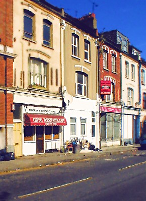
A very mixed commercial and residential thoroughfare in south-east Stoke Newington. In the early centuries of its life the
road was the northern part of Shacklewell Lane, which looped from Dalston to Stoke Newington Common. In 1864 the Great Eastern Railway Company gained permission to
build a branch line running to the east. Builders quickly grabbed the opportunity to replace market gardens with houses along
this section of the lane, which was renamed Rectory Road. In those days the road connected with Stoke Newington Church Street,
which led on to St Mary’s church and its rectory (both rebuilt in the 1850s). The railway line opened in 1872, as did
Rectory Road station, which is actually on Evering Road. Soon afterwards the route to Church Street was diverted when development
around Garnham Street blocked the way, forcing travellers onto Northwold Road. As housing filled the neighbourhood ever more
densely the street’s character slipped inevitably downmarket. Landowner the Tyssen estate was given permission to convert
some of the larger houses to industrial use in 1933 after warning the council that the alternative was multi-occupation. Rectory
Road station was rebuilt in the 1970s. Nowadays, the neighbourhood is dominated by council towers looking down on turn-of-the
century terraces. For most of its length, Rectory Road is part of the Stoke Newington one-way system, deflecting City-bound
A10 traffic away from the High Street. Three early nineteenth century houses survive at the southern end of the road, and
are grade II listed. Rectory ward was abolished at the last boundary reorganisation and Rectory Road now divides the wards
of Hackney Downs and Stoke Newington Central.
|