|
A residential district lying south of Hornchurch,
interspersed with commerce and industry, particularly along New Road. Because of its situation beside the Ingrebourne River,
with access to the Thames via Rainham Creek, there appears to have been human occupation of the area virtually since the ice
retreated. Prehistoric implements have been found in the marshes and there is evidence of a Saxon burial ground. The name
is probably a corruption of Reoginga-ham, Saxon for ‘settlement of the ruling people’. Rainham grew rapidly from
the end of the nineteenth century, following the typical pattern that begins with larger villas for the well-off and then
gives way to cheaper accommodation for the masses as advancements in transport provide improved accessibility. Since 1945,
Rainham has doubled in size with the seemingly uncontrolled construction of housing on former farmland north of the A13, where
there is also a large Jewish cemetery. Beyond this is Launders Lane, where London’s only road bowling contests used
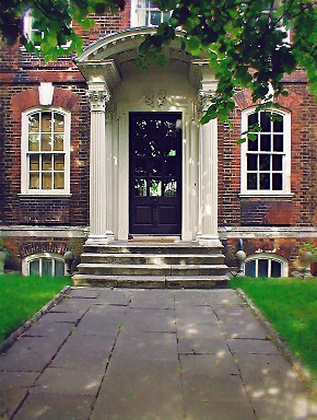
to take place on Sunday afternoons until a few years ago. The impressive Rainham Hall is a National Trust property, but its
opening hours are extremely limited. There are sufficient remaining elements of old Rainham to suggest what a charming marshland
village this once was, but these have been engulfed by unsightly additions from the second half of the twentieth century.
Rainham Hall and the neighbouring church of St Helen and St Giles, for example, gaze across the road at a library and social
services offices that are truly offensive.
|