|
A scattered collection of small farms and civic amenities situated north of Ickenham and west of Ruislip, and surrounded on
all sides by green-belt farmland. The origin of the name, which is also spelt as three separate words, is uncertain. It is
probably a corruption of a landowner’s name but may refer to annual festivities – which would have been held on
‘Lady Day’, the feast of the Annunciation of the Blessed Virgin on 25 March, which was reckoned as the beginning
of the year in England from the Middle Ages until 1752. Drawn in 1754, Rocque’s map of Middlesex shows a small group
of dwellings here. The dog-leg bend in Newyears Green Lane marks the point where the road used to fork off across Harefield
Lane (now Breakspear Road) to Ickenham but this route was closed after the enclosure of the fields in 1813. Despite its rural
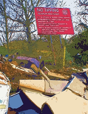
setting and idyllic name, much of Newyears Green is literally a dump. Newyears Green Lane has a recycling centre, waste transfer
station and car breaker’s yard. Not content with these facilities, flytippers deposit their loads in every available
lay-by – usually right in front of the council’s ‘no tipping’ signs.
Dews Farm Sandpits, alongside Harvil Road, are managed by the London Wildlife Trust. There is woodland and scrub around varied
grassland rich in flowers and insects.
|