|
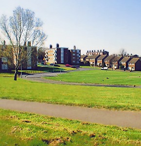
An unofficial new town situated in the far east of the borough, set on a steep hillside rising into the North Downs by nearly
200 feet along its north-south axis. New Addington’s centre lies 2½ miles south of the nearest train station, at West
Wickham. Domesday Book records that, “Albert the clerk holds of the king Addington. Osweard held it of King Edward. It was then assessed at
eight hides; now at two. There is land for four ploughs… woodland for 20 pigs.” This was the manor later known
as Addington Temple, which covered roughly the area of modern New Addington. It remained as farmland well into the twentieth
century. In 1935 the First National Housing Trust acquired 569 acres of Fisher’s Farm to lay out a garden village. Croydon
council supported the plan as a way of reducing the over-crowding in its semi-slum urban areas. By the time the outbreak of
war brought a halt to construction just over a thousand homes had been built. After the war housing need had become even more
pressing, but there was also pressure to protect London’s countryside. The borough took over the housing trust’s
unused land and acquired a further 400 acres, while the land west of Lodge Lane was declared green belt. The plan was completed
by 1963, but continuing housing need prompted another extension to New Addington five years later. This latter part is known
as the Fieldway estate and has become the most disadvantaged part of the district. As one of the largest estates in London
without any nearby rail services, New Addington’s inaccessibility was a major reason for the creation of Croydon Tramlink,
which arrived here in 2000. Fieldway and New Addington are the borough’s first and second most deprived wards and are
the principal recipients of its regeneration funds. A 2001 planning document declared the council’s aim to counter the
perception that, “if you come to live in New Addington, you’ve failed.”
|