|
A remote hamlet situated on the Ridgeway (A1005), which links west Enfield with the M25 at Potters Bar. It takes its name
from the former Australian penal colony, implying an isolated settlement in the same way that ‘World’s End’
was used two miles to the south. The hamlet came into being after the enclosure of Enfield Chase in 1777 and it had gained
its cheeky name by 1819, when C G Greenwood identified it on his map of Middlesex. Botany Bay has been home to a series of
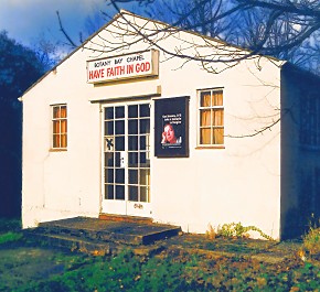
simple chapels during its short life and still has one today. The first was in existence by 1851 and had links with a now-obscure
evangelical sect called the Countess of Huntingdon’s Connexion, but it did not see out the century. Terraced cottages
and some of the larger properties are of Victorian origin, while 20th-century amenities include the Robin Hood public house
and a farm shop. Botany Bay Cricket Club is located on East Lodge Lane and since 2000 the Right Start Montessori School has
operated from a unit in its grounds. In 2001 Enfield council contemplated relocating Enfield golf course to Rectory Farm but
the incoming Conservative administration abandoned the proposal a year later. The council firmly opposes attempts to develop
Botany Bay in almost any way, stating that ‘the character and prominent ridge-top location of the village means that
no sites exist where further building development will not harm the green belt setting or the landscape of the Enfield Chase
heritage area. The council will therefore resist development on backland sites, in spacious gardens and grounds, and in substantial
gaps along road frontages.’
|