|
|
 |
|
Barking & Dagenham
|
|
|
A gargantuan council estate covering four square miles of former fields, heath and parkland north of Dagenham. It has been
claimed that its name was shortened to the present form because Beacontree, an old local name, was one letter too long to
fit on bus destination blinds. However, there is little evidence for this since both spellings have been in use for centuries.
Some modern maps and a couple of local shops still prefer the alternative spelling. Much of the area was part of Parsloes,
once the largest manor in Dagenham and the property of the Passelewe family in 1257. The most recent incarnation of the manor
house was demolished in 1925 owing to its dilapidated condition. Valence House, the district’s only other piece of heritage,
was preserved as a showpiece for the new estate. Begun in 1921, Becontree was the flagship of the London County Council’s
‘cottage estate’ housebuilding programme and was intended to accommodate 100,000 people. Most of the houses were
constructed in red brick with tiled roofs, although many of the walls have since been pebble-dashed or stone-clad. A railway
line brought materials from the Thames docks and 50 miles of roads were laid out for what was called the world’s greatest
public housing project. Parsloes Park was opened to the public as part of the ceremony marking the inauguration of the estate.
Many of the first residents came from Limehouse, where a slum clearance programme was under way at the time. By the 1930s,
Becontree had grown larger than many provincial cities. But the LCC’s ambitions could not be fully realized on an estate
so lacking in education, healthcare and social facilities; and the housing, though adequate, was plain and monotonous. Had
it not been for the creation of the Ford motor works, unemployment would have been an added burden. Some of the estate’s
early drawbacks have been overcome but the township is still not well-endowed with amenities. With the trends towards smaller
families and more people living alone, Becontree’s population is now much smaller than originally envisaged.
|
|
|
|
|
|
|
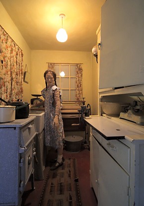
| A re-creation of an original Becontree kitchen in a tableau at Valence House |
Most residents are white, but there is also a sizeable black British community, of Caribbean and African descent. Bengali,
Urdu, Punjabi and Albanian are among the minority languages spoken.
|
|
|
|
|
|
|
Postcode areas: Dagenham RM8, RM9 and RM10
Population: 29,874 (Becontree, Valence and Heath wards)
Station: District Line (zone 5)
Further reading: Robert Home, ‘A Township Complete in Itself’, Barking & Dagenham Libraries and UEL School of
Surveying, 1997
and Andrzej Olechnowicz, Working-Class Housing in England between the Wars: The Becontree Estate, Clarendon Press, 1997
Text and selected images are reproduced with the permission
of Chambers but may differ from the published versions
All content © 2005–2010
|
|
|
|
