|
A stereotypical east London district, situated in the borough of the same name. Little of Walford’s history is known
prior to 1985. Its name may be connected with the nineteenth century London historian Edward Walford or perhaps indicates
early settlement of the area by Celts, as is also likely in the cases of Walworth and Wallington, (the Old English word ‘wala’
has the same root as ‘Wales’). The ford could have crossed one of the tributaries of the River Lea, but Walford’s
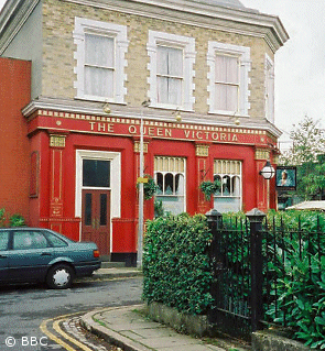
precise location is difficult to pin down. The architecture of the surprisingly busy Albert Square appears to date from around
the 1880s and bears a close resemblance to part of Fassett Square, on the Hackney/Dalston border. However, aerial views have
centred on Poplar and Canning Town, while Walford East tube station seems to lie to the east of Bow Road. Unlike many east
London quarters, the population is still primarily white working class, although various ethnic minorities manifest a token
presence. Living standards seem relatively acceptable, though there are characteristics that would normally be indicators
of deprivation. The best opportunity for exercise seems to be a walk in the park or ‘on the marshes’. There are
no high street names among the shops, no Tesco Metro, not even a Budgens. No bank or building society. At least there’s
still a post office.
|