|
The former heartland of London’s Irish community, now more multicultural, located north-west of St John’s Wood
and Maida Vale. The name comes from a stream (which could have been ‘cold bourne’, ‘cow’s bourne’
or ‘King’s bourne’) that formerly constituted the upper part of the River Westbourne. Kilburn Priory was
founded in the twelfth century on the site of a former hermitage and the Red Lion, which was said to date from 1444, may have
begun life as the priory’s guest house. The settlement grew as a minor halt on the London to St Albans road, with coaching
inns built to serve the travellers along the stretch of Watling Street that is now Kilburn High Road (A5). A medicinal well
was discovered near the Bell inn in the early 18th century and a pleasure garden was laid out in imitation of the one at Hampstead.
After abortive attempts at estate building in the 1820s, the large houses and farms that had previously lined the main road
were demolished to make way for terraces of houses, the first of which was built in 1850 after the opening of Kilburn station
on the London to Birmingham line. At the same time, villas for the upper middle classes were built on the former estate of
Kilburn Priory. Outlying areas like Brondesbury, Shoot Up Hill and West Kilburn were developed from the 1860s. A number of
private schools opened, including one run by A A Milne’s father, which the writer attended, as did H G Wells and the
newspaper proprietor Alfred Harmsworth. The district became poorer later in the century, the schools closed, large houses
were subdivided or took in lodgers, and a variety of immigrants began to move here, especially the Irish. Kilburn became a
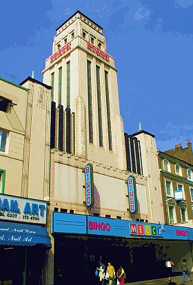
popular place for public entertainment and entrepreneurs established several variety theatres. When the Gaumont State opened
here in 1937 it was Europe’s largest cinema, with 4,000 seats. Much of the present housing in Kilburn is the result
of slum clearance programmes in the 1930s and the replacement of bomb-damaged properties after World War II. Municipal authorities
built several estates of flats into the 1970s and Irish settlers were joined by West Indians, Indians and Pakistanis. A few
years ago, Kilburn High Road was named the ‘Music Mile’ by the London Tourist Board, with Irish and country music
the main specialities, performed at pubs like Biddy Mulligan’s. Nearly all these establishments have now gone and the
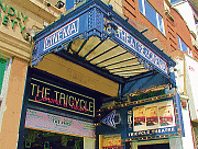
Music Mile is no more, although several pubs still have an Irish flavour and/or clientele. The Tricycle Theatre is the district’s
leading cultural venue.
 |