|
|
 |
|
Sutton
|
|
A favoured interwar suburb with some impressive older houses and cottages, situated west of Sutton. The name may be a corruption
of two words meaning ‘village by the tree stumps’. Cheam was granted to the cathedral priory of Christchurch,
Canterbury in 1018 and a church built soon afterwards was dedicated to a former archbishop, St Dunstan. The village had around
150 inhabitants at the time of Domesday Book, when the archbishop owned five slaves. By the 14th century Cheam had been split
into east and west manors, each of which had its own village. East Cheam (later known as Lower Cheam) was the larger of the
pair. From the 14th to the 16th century Cheam was known for its potteries, which specialized in making jugs. Whitehall was
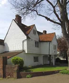
built on Malden Road around 1500 and is outer London’s finest remaining example of a medieval hall house. The house
was later extended and weatherboarded and is now open to the public. Henry VIII acquired the manors of Cheam after commissioning
the construction of Nonsuch Palace in the neighbouring parish of Cuddington in 1538. Cheam School was founded sometime before 1646, and may have used either Whitehall or West Cheam manor house as its
original home. The manor house was demolished in 1796. At the 1801 census, the 616 inhabitants were concentrated in three
clusters: around Whitehall, around the church and on the High Street. On the north side of the parish, Cheam Common was enclosed
by 1810. When Cheam station opened in 1847, it had at first little effect on the character of the village. St Dunstan’s
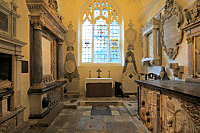
was rebuilt in 1864 but the chancel of the medieval church was preserved as the Lumley chapel, the borough’s oldest
building (see image below). By the outbreak of World War I, housing was spreading here from Sutton and in the 1920s the old
village was overwhelmed by houses and shops, many built in mock-Tudor style. The High Street was blighted by road widening
but a medieval cottage was saved by moving it to its present site on the Broadway in 1922. The new district of North Cheam
grew up to the east of Worcester Park in the 1930s. The suburb had largely assumed its present-day appearance by 1939, with
terraced and semi-detached homes filling the north of the district and larger detached properties in the south.
 |
|
|
|
|
|
|
|
Postcode areas: Sutton SM3, SM2 and
SM1
Population: 9,695
Station: Southern (zone 5)
Further reading: Martin Andrew, Francis Frith’s Around Cheam , Francis Frith Collection, 2005 , Francis Frith Collection, 2005
and Sara Goodwins, Cheam Past and Present, Sutton, 2003
Text and selected images are reproduced with the permission
of Chambers but may differ from the published versions
All content © 2005–2010
|
|
|
|